
What are the oldest international borders in the world?
Explore the world's oldest surviving borders, from Portugal and Spain to Andorra and San Marino, and why their age is difficult to define.
10 min read · English
32 articles
Explore the world's oldest surviving borders, from Portugal and Spain to Andorra and San Marino, and why their age is difficult to define.

Discover why much of the US–Canada border follows the 49th parallel, how British-American treaties shaped it, and why the line is not entirely straight.

Discover why Switzerland has 26 cantons, how medieval alliances became a federal state, and why cantonal autonomy still shapes the country.

Explore how Yugoslavia's collapse, the Bosnian War and the Dayton Peace Agreement shaped Republika Srpska's place within Bosnia and Herzegovina.

Discover how Ulster's history, partition in 1921–1922 and the Good Friday Agreement shaped Northern Ireland's position within the United Kingdom.

Explore how colonial diplomacy, surveying and post-independence decisions shaped Africa's straight borders—and why the Berlin Conference is only part of the story.

Trace Quebec's path from New France and British conquest to Confederation in 1867, and explore how language, law and sovereignty debates shaped its place in Canada.

Explore how Mexican frontier settlement, slavery, the Texas Revolution and annexation in 1845 brought Texas into the United States and helped trigger war with Mexico.

Trace Budjak's history from an Ottoman frontier through Russian and Romanian rule to the Soviet division of Bessarabia and Ukrainian independence in 1991.

Trace Greenland's connections with Norway and Denmark, its colonial history, and the development of Home Rule and Self-Government.
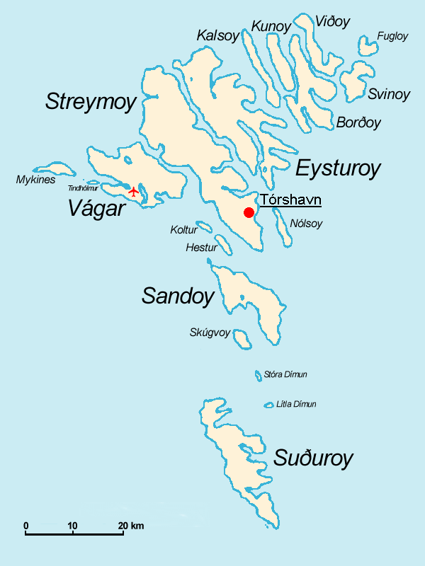
Discover how Norse settlement, the Denmark–Norway union, the Treaty of Kiel and Faroese Home Rule shaped the islands’ place in the Kingdom of Denmark.

Explore how the 1945 occupation zones, Cold War rivalry and Korean War created the border and Demilitarized Zone between North and South Korea.

Explore how Russian and Soviet rule, national identity, Transnistria and the choices of 1991 shaped Moldova’s independence from Romania.

Explore how the collapse of Austria-Hungary and the Treaty of Trianon reshaped Central Europe, divided the Hungarian kingdom and created lasting minority questions.

Discover how inaccurate maps, the port of Toledo and the politics of statehood sparked the Toledo War and helped shape Michigan’s Upper Peninsula.

Explore how competing surveys, tax collection and militia mobilization sparked the Honey War, and how the Supreme Court settled the Missouri–Iowa border.

Discover how an 1834 compact, artificial land reclamation and a 1998 Supreme Court ruling divided Ellis Island between New York and New Jersey.
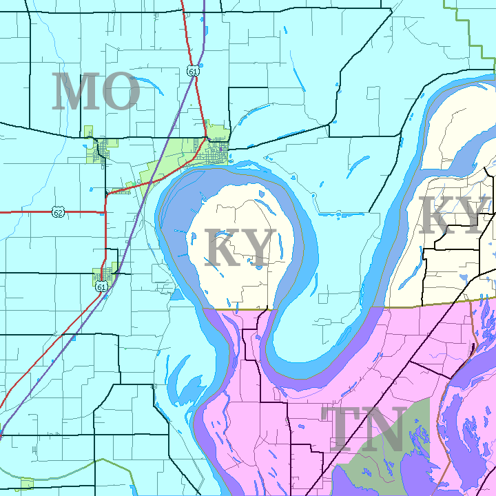
Explore how colonial latitude lines, surveying errors and a Mississippi River meander created the Kentucky Bend, an isolated part of Kentucky reached by road through Tennessee.

Discover how colonial land grants, the Twelve-Mile Circle and centuries of surveying shaped Delaware’s curved border and the disputed Wedge.

Explore how colonial surveying errors, disputes over entire towns and the compromise of 1804 created the Southwick Jog on the Massachusetts–Connecticut border.

Explore how British coastal administration, the 1927 Privy Council ruling and Newfoundland’s entry into Canada shaped the Quebec–Labrador boundary.

Discover how rival police forces, railway expansion and colonial boundary claims turned Kenora into a town governed by both Ontario and Manitoba.

Trace Switzerland’s formation from medieval Alpine alliances through religious conflicts, Napoleon’s reforms and the federal constitution of 1848.

Trace Prussia’s rise, its rivalry with Austria and Bismarck’s wars of unification, and discover why Germany survived the eventual abolition of Prussia.

Explore how colonial rule, the independence movement, partition and the integration of princely states shaped modern India and its federal constitution.

Explore how colonial rule, competing national movements, the collapse of power-sharing and the events of 1974 created Cyprus’s enduring division and Green Line.

Explore Romania’s changing twentieth-century borders, from the creation of Greater Romania to wartime territorial losses and the postwar settlement.

Discover how medieval land ownership created the intricate enclaves of Baarle-Hertog and Baarle-Nassau, where the Belgian–Dutch border crosses streets and buildings.
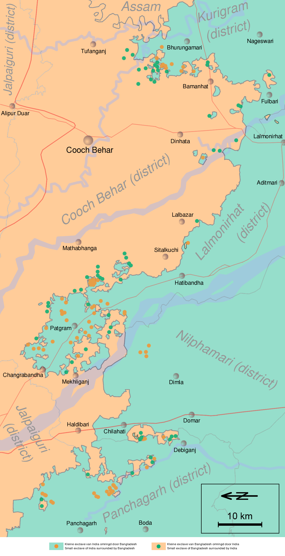
Explore the origins of the India–Bangladesh enclaves, their impact on residents and the 2015 land boundary agreement that resolved most of this intricate border.

Explore the colonial negotiations and ambitions for access to the Zambezi that created Namibia’s Caprivi Strip and shaped its unusual northeastern border.

Discover how two competing Egypt–Sudan boundaries left Bir Tawil unclaimed by either state while both seek sovereignty over the Halaib Triangle.

Explore how the Great Game and imperial boundary agreements created Afghanistan’s Wakhan Corridor, a mountainous buffer extending to China.